
Fieldwork, Sampling, and Site Diagnostics
This section highlights some moments from the field, collecting samples, conducting site observations, and visiting industrial and mining operations. These activities form the foundation of my data-driven research and allow me to connect lab-based analysis with real-world geological contexts.


.jpg)


Laboratory Methods & Geochemical Testing
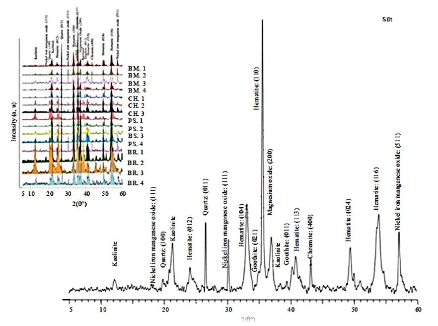
I have applied various analytical techniques to study Earth materials, including elemental and mineralogical analyses (ICP-MS, XRD, XRF) and advanced imaging with X-ray microtomography (micro-CT) to examine microstructures. I also gained experience with synchrotron-based spectroscopy (XAFS) for speciation analysis. I have conducted geochemical leaching and partitioning tests (SSE, TCLP) to assess metal mobility and fractionation.


Data Analysis Tools


01.
3D imaging and analysis
Tools used: Dragonfly, ImageJ
Reconstructing and analyzing micro-CT and mineral structure data to support micro-scale interpretation and 3D visualizations.
02.
Spatial Mapping and GIS
Tools used: ArcGIS
Creating and interpreting geospatial data layers, contamination modeling, and field site visualization using professional GIS tools.
03.
Statistical Analysis & Visualization
Tools used: SPSS, Grapher
Performing data cleaning, statistical correlation, and source plotting to interpret complex geochemical and environmental data.
04.
Reporting and Infographics
Tools used: Adobe Illustrator, Edraw Max
Designing technical reports, data-driven infographics, and clear visuals for scientific publications and stakeholder communication.